Pangea Breakup and Continental Drift,  Physical Puzzle


What is in the Pangea Puzzle Download Packages?


These are images of the hand-drawn "flat earth" continents that Atwater constructed for the Pangea movies in the previous section. These images can be printed and cut up to make a physical puzzle. There are two download versions: one for output on a regular color printer and the other for output on a large plotter.


Package 1 contains a pdf file with eight letter-size pages (7.5"x10") for output on a regular color printer. Note: in order to keep the continental pieces large enough, Eurasia has been split onto two pages and will need to be reassembled.


Download Pangea puzzle package 1: pdf file with eight pages for a regular color printer (25 MB)


Package 2 contains a large jpeg file (40"x15") for output on a large plotter.


Download Pangea puzzle package 2: one jpeg image for a large plotter (1.6 MB)


Construction (of either version): A medium-sized puzzle with good fits can be made by printing them out, laminating them and/or gluing them onto foam board, and then carefully cutting out the individual continents along their edge lines. Small pictures of the pieces arranged in their Present and Pangean Configurations are included. Try out these constructions with your pieces and trim any edges, if needed, to make them fit well in both configurations.

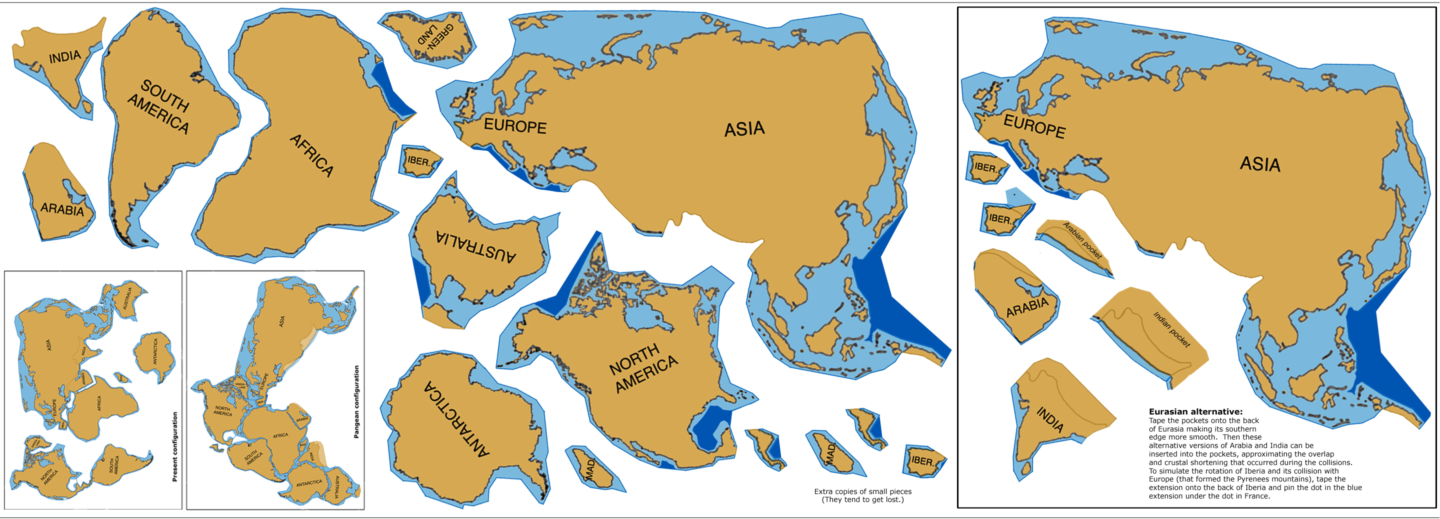
Geological complication in the continental collision zones: Note that significant continental overlaps occur when India, Arabia, and Iberia collide with the southern edges of Eurasia. The Earth responded to this problem by shortening, thickening and stacking the crust to form mountain belts. Two alternatives are offered in this puzzle. In the simpler version, you can just use the supplied images of Eurasia, India, Arabia, and Iberia with their edges having pre-cut dents, artificially anticipating the collisions.
A version that starts out with smoother continental edges can be constructed by taping the Indian and Arabian "pockets" onto the back of Eurasia and then using the extended versions of India and Arabia. The latter can then be inserted into the pockets, simulating the collisions.
Iberia (Portugal and Spain) has an especially interesting history. From its Pangean location, it simply rotated around a pole in France, opening the Bay of Biscay and pushing up the Pyrenees mountains between France and Spain. If you pin the extended version of Iberia to the underside of France, it will do this rotation automatically as Africa scrapes by during its motion away from North America. (With a thumb tack on the underside, pin the dot on the blue extension of Iberia to the dot in France.)

Puzzle backboard. When I made this puzzle for my own use, I wrapped some thick, fuzzy blue cloth around a board to use as the background. (The fuzziness helps the pieces stay put better.)

About the continental shapes. The continental shapes in this "flat earth" depiction were not mathematically derived. Rather, Atwater hand-created them from tracings of a globe, warping them so that they would be flat, recognizable, and would fit together in both their Pangean and present-day configurations. Note that I had to seriously contort Northeastern Eurasia in order to make the rest of the continental fits work on a flat earth.


Feedback please: I'd love to hear how this puzzle works for you and any suggestions for how to make the images or description more useful: atwater@geol.ucsb.edu


return to Download page